

Bromo Tengger Semeru National Park- Unworldly Landscapes In Indonesia

You might feel like you imagination has taken a trip to Mars when you look out your window and see the unworldly landscapes, unusual sunrise, strange clouds and even stranger colors, but if you are waking up in the Bromo-Tengger-Semeru National Park, you are not dreaming as this picture fits the park perfectly.
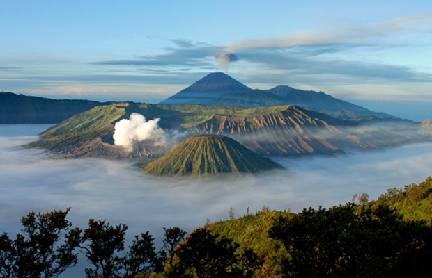
Located in the Southeast of Surabaya, which is the capital of East Java in Indonesia, the Bromo Tengger Semeru National Park is Indonesia’s only conservation area that has a sand sea. The Tengger Sand Sea is the caldera of an ancient volcano – Tengger, which has four new volcanic cones. The Sand Sea covers an area of 5,250 hectares and is at an altitude of about 2,100 meters.
The Bromo Tengger Semeru National Park got its name from Mount Bromo – 2,329 meters high and is easily recognized because it has a constant cloud of steam and smoke belching from its crater Mount Semeru – 3,676 meters high and considered the highest mountain in Java and Tengger, who were the people who inhabited the area many hundreds of years ago.
Besides the unusual, the park also has lush green valleys and a tropical rain forest that is fed by rivers and can be found at the parks lowest elevation and furthest away from the sand sea. Even though you can see Eagles and Hawks soaring along the plateau, the park is not renowned for birdwatching. In the valley areas, you may get lucky and see such mammals like Java rusa deer, a Leopard, Wild pigs or Marbled cats.
TRAVEL TO BROMO TENGGER SEMERU NATIONAL PARK
You can take a plane to the airport in Surabaya, Indonesia, which get regular service from Jakarta, Bali as well as other Asian countries. Once at the Surabaya Airport, you have the choice of either of the three well established routes into the park:
- Surabaya – Probolinggo → Ngadisari Route, which is on the north coast of Java and about 145 km from the park.
- Surabaya – Pasuruan – Tosari Route, it is a bit more difficult than the Probolinggo route, but Pasuruan is much closer to Surabaya.
- Surabaya à Malang → Tumpang. This route is an approach from the Southeast


